
Herefordshire Maps
Shropshire Maps
( Page 1 of 3 )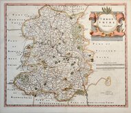
Robert Morden 1695 [1753]
Emanuel Bowen 1720
Thomas Kitchin 1763
Thomas Kitchin 1763
Joseph Ellis 1765 [1773]
Emanuel Bowen 1767 [1770]
John Haywood 1788
John Cary 1789 [1805]


42x36 cm
FIRST MAP OF THE COUNTY TO SHOW LONGITUDE FROM LONDON.
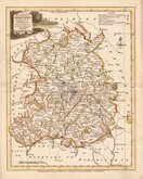
SHROP SHIRE
By Robert Morden
Sold by { Abel Swale Awnsham and John Churchill
Copper engraving produced by Robert Morden for publication in Edmund Gibson's translation of William Camden's Britannia first published by Abel Swalle and Awnsham & John Churchill in 1695.
This is the first series of maps to mark longitude in minutes of time (top border) as well as in degrees (bottom border). For most counties, including this Shropshire map, longitude is based on the meridian of St. Paul's, London. They were also the first folio sized series of county maps to show roads, Morden using the survey and road maps of John Ogilby published in his road book, also entitled Britannia, in 1675. Morden did not use Ogilby's standardisation of measure for the mile at 1760 yards, preferring a somewhat arbitrary approximation of local variations of the mile, to include three scales; 'Great', 'Middle' and 'Small’, but this Shropshire map departs from this standard for the work and, in line with Ogilby’s includes two scales of “Computed” and “Measured” miles, though he gives no measure for the scales. The work was republished in 1722, 1730, 1753 and, finally in 1772. The plate was updated for the 1722 edition mostly with changes to place name spellings and was reworked for the 1753 edition due to wear on the plate.
Some light offsetting (ink shadow transferred by evaporation to the opposite side of the folded page) but a good dark impression on strong paper with good margins all round in fine later hand colour from the 1753 edition.
Quick Links


Staffordshire Maps

Wales Maps
×