
Dorset Maps
Devon Maps
( Page 1 of 2 )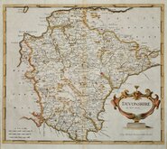
Robert Morden 1695
Owen & Bowen 1720
Thomas Kitchin 1750 [1769]
Henry Cooper 1808
Rowe Robert 1816 [1831]

William Pinnock 1819 [1823]
Sidney Hall 1820 [1834]
John Cary 1822


43x36 cm
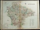
DEVONSHIRE
By Rob.rt Morden.
Sold by Abel Swale Awnsham & Iohn Churchil.
Copper engraving produced by Robert Morden for publication in Edmund Gibson's translation of William Camden's Britannia first published by Abel Swalle and Awnsham & John Churchill in 1695. This is the first series of maps to mark longitude in minutes of time (top border) as well as in degrees (bottom border). For most counties, including this Devon map, longitude is based on the meridian of St. Paul's, London. They were the first folio sized series of county maps to show roads, Morden using the survey and strip road maps of John Ogilby published in his road book, also entitled Britannia, in 1675.
The work was republished in 1722, 1730, 1753 and, finally in 1772. The plate was updated for the 1722 edition mostly with changes to place name spellings and was reworked for the 1753 edition due to wear on the plate.
This fine example, in neat hand colour, is from the first edition of 1695.
Ref. Batten & Bennet, Printed Maps of Devon. 21.1
Quick Links


Somerset Maps
Cornwall Maps
×